


Swiss Drone Maps
คำอธิบายของSwiss Drone Maps
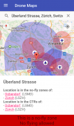
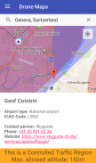
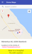
นักบินโดรนและเครื่องบินจำลองสามารถใช้ Swiss Drone Maps เพื่อติดตามสถานที่ที่ได้รับอนุญาตให้บินได้ เขตห้ามบินและพื้นที่การจราจรที่มีการควบคุมจะมีสีเฉพาะบนแผนที่จึงมองเห็นได้ง่าย สนามบินและลานจอดเฮลิคอปเตอร์สามารถมองเห็นได้ชัดเจนด้วยเครื่องหมายที่ใช้งานง่ายบนแผนที่
ที่ระดับการซูมที่สูงขึ้น แผนที่จะแสดงข้อมูลเพิ่มเติมที่เกี่ยวข้อง เช่น โรงพยาบาลและสนามบินบนภูเขา การเลือกเครื่องหมายระบุสถานที่ไม่เพียงแต่แสดงข้อมูลเกี่ยวกับพื้นที่ แต่ยังรวมถึงหมายเลขโทรศัพท์และเว็บไซต์ของสนามบินด้วย ข้อมูลการติดต่อนี้ช่วยให้สามารถยื่นขอใบอนุญาตการบินพิเศษได้เองและง่ายดาย
ข้อสงวนสิทธิ์: เราไม่สามารถรับประกันความถูกต้องหรือความถูกต้องได้ 100% และปฏิเสธความรับผิดใดๆ และทั้งหมด แอพนี้ได้รับการพัฒนาเป็นการส่วนตัว ขึ้นอยู่กับข้อมูลที่เปิดเผยต่อสาธารณะจากแหล่งข้อมูลทั้งภาครัฐและเอกชน (ดูรายละเอียด https://opendata.swiss/de/organization/bundesamt-fur-zivilluftfahrt-bazl) อย่างไรก็ตาม นักพัฒนาไม่มีอำนาจทางกฎหมายใด ๆ และไม่ได้มีส่วนเกี่ยวข้องกับรัฐบาลสวิสในทางใดทางหนึ่ง (นอกเหนือจากการจ่ายภาษีให้กับรัฐบาล)
Swiss Drone Maps--เวอร์ชั่น20.9
(20-03-2025)Swiss Drone Maps - ข้อมูล APK
เวอร์ชั่น APK: 20.9แพ็คเกจ: ch.abwesend.dronemapsเวอร์ชั่นล่าสุดของSwiss Drone Maps
เวอร์ชั่นอื่น


แอปในประเภทเดียวกัน


